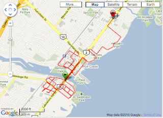
To view statistical information and GPS mapping from today's attempt click on image

I start out at the Lighthouse situated on the west side of Credi River, at 105 Lakeshore Rd W.
Cycling south along Front St S, (original eastern border of Port Credit ); L - Lake St; L - Mississauga Rd S (originally delineated western border of Port Credit when it was named Joseph Street after Mississauga Chief Joseph Sawyer); R - Port St W; R - Front St S; R - Bay St; R - Mississauga Rd S; R - Lakeshore Rd W; R - John St S; R - Lake St; R - Peter St S; R - Lakeshore Rd W; L - John St; R - High St; R - Front St N; R - Lakeshore Rd W; R - Mississauga Rd N; R - Park St W; R - Peter St N; R - Mississauga Rd N; R - Front St N; R - Park St W; R - Peter St N; R - Front St N; 5.5km; cross Lakeshore Rd W ...
---Cycling south along Front St S, (original eastern border of Port Credit ); L - Lake St; L - Mississauga Rd S (originally delineated western border of Port Credit when it was named Joseph Street after Mississauga Chief Joseph Sawyer); R - Port St W; R - Front St S; R - Bay St; R - Mississauga Rd S; R - Lakeshore Rd W; R - John St S; R - Lake St; R - Peter St S; R - Lakeshore Rd W; L - John St; R - High St; R - Front St N; R - Lakeshore Rd W; R - Mississauga Rd N; R - Park St W; R - Peter St N; R - Mississauga Rd N; R - Front St N; R - Park St W; R - Peter St N; R - Front St N; 5.5km; cross Lakeshore Rd W ...
I then move on to the extension of Port Credit planned in 1846, on the eastern edge of the Credit River, cycling south through JJ Plaus Park along path to southern tip of pier (take in view of Lake Ontario, and look west toward Old Village where I have just cycled); I loop back, passing a couple on a park bench too engaged with each other to notice my passing. Wonder how much of that may have been caught on my handlebar cam.
I exit through the parking lot ... R - Port St E; L - Helene St S; R - Park St E; R - Hurontario St (becomes eastern border of Port Credit when it was called Huron St); R - Ann St; R - Queen St E to end of parking lot then loop back (becomes northern border of Port Credit); L - Stavebank Rd N; R - Park St E into Memorial Park ... a bit difficult to navigate park today as there are trucks parked all over the place with staging and scaffolding equipment piled on grass and paths. City staff are busy preparing for the Mississauga Marathon, taking place on Sunday. Memorial Park is the location for the finish, and post run activities.
I quickly exit via High St; and cycle east; L - Elizabeth St N; R - Park St E; L - Helene St N; L - Queen St E; L - Elizabeth St N; R - Park St E; L - Stavebank St N; R - Lakeshore Rd E ... so far I have cycled 12km
---
Then head west along Lakeshore Rd, passing Mississauga Rd (the original western border of Port Credit) and cycle through neighbourhoods developed in the 1880s, extending the town further west ... R - Wesley Ave; L - High St W; R - Wesley Cr then loop back; R - High St W to end then loop back; L - Wesley Ave; L - Park St W to end then loop back; L - Wesley Ave to end loop back; L - Queen St W; R - Mississauga Rd N; R - Park St W; L - Wesley Ave; L - High St W; R - Mississauga Rd N; L - Lakeshore Rd W ... I have now cycled about 15km
---
My route back tracks along Lakeshore Rd toward the neighbourhood originally called Credit Grove that was planned in 1910 and which extended Port Credit north of Lakeshore Rd E and south of the train tracks, and east to the border of what was then the Township of Toronto.
... left onto Mohawk Ave; L - Forest Ave; L - Brant Ave; R - Lakeshore Rd E; R - Briarwood Ave; L - Forest Ave; L - Oakwood Ave N; R - Lakeshore Rd E; R - Woodlawn Ave; L - Forest Ave; L - Elmwood Ave N; R - Lakeshore Rd E; R - Rosewood Ave; R - Forest Ave; L - Elmwood Ave N; R - Queen St E; R - Woodlawn Ave; L - Forest Ave; L - Oakwood Ave; R - Queen St E; R - Briarwood Ave; L - Forest Ave; L - Cayuga Ave to end then loop back; L - Iroquois Ave; R - Seneca Ave (becomes eastern border of Port Credit and western edge of the Township of Toronto, runs parallel to the Credit River, as did the eastern border of the Credit Indian Reserve); R - Lakeshore Rd E; R - Cayuga Ave; R - Forest Ave; R - Seneca Ave; R - Tecumseth Ave ; R - Cayuga Ave; R - Forest Ave; L - Seneca Ave; L - Queen St E; L - Rosewood Ave; R - Park St E; L - Hurontario St which becomes St Lawrence Dr south of Lakeshore Rd E; 21.5km; R - Port St E; L - Helene St S ; then left onto bike path and cycle through Tall Oaks Park. I pause to take in the view of Lake Ontario and the notice how busy this area is with pedestrian and bike traffic ... my route has now covered 20 odd km
---
In 1921 a plan was drawn up for a new neighbourhood called Hiawatha-on-the-lake situated just south of Credit Grove to Lake Ontario and east to the border of the Township of Toronto.
... L - Elmwood Ave S; R - Lakeshore Rd; R - Oakwood Ave S to end loop back; R - Wanita Rd; R - Cumberland Dr to end loop back; R - Wenonah Dr; R - Onaway Rd then loop back ; R - Wenonah Dr; R - Wanita Rd then loop back; R - Wenonah Dr; R - Minnewawa Rd then loop back; R - Wenonah Dr then loop back at Lakeshore Rd; R - Minnewawa Rd; R - Cumberland Dr; R - Lakeshore Rd; R - Hiawatha Pkwy; R - Onaway Rd; R - Cumberland Dr; R - Wanita Rd; R - Wenonah Dr; R - Onaway Rd; L - Hiawatha Pkwy; R - Cumberland Dr; R - Minnewawa Rd; R - Hiawatha Pkwy; R - Wanita Rd; R - Elmwood Ave S; L - Lakeshore Rd E ... have cycled about 30km
---
In the 1940-50s neighbourhoods were established around Ben Machree and Maple Avenues extending Port Credit's border west to Shawnmarr Rd.
... R - Pine Ave N; R - Queen St W; R - Benson Ave; L - High St W then loop back; R - Harrison Ave; L - Queen St W; L - Benson Ave; R - Lakeshore Rd W; R - Pine Ave N; L - Queen St W; L - Shawnmarr Rd (western border of Port Credit, the border runs parallel to the Credit River, as did the western border of the Credit Indian Reserve); L - Lakeshore Rd W; R - Pine Ave S; merge with Maple Ave S; R - Ben Machree Dr; L - Ben Machree Dr; R - Godfrey Lane; R - Lakeshore Rd W; R - Ben Machree Dr; R - Maple Ave S loop back continue north on Maple Ave; L - Queen St W; L - Broadview Ave; R - Lakeshore Rd W; R - Godfrey Lane N; L - Queen St W; L - Shawnmarr Rd and cross Lakeshore Rd W into Rhododendron Gardens and follow a nicely paved bike path toward lake, then east; L - Godfrey Lane; R - Lakeshore Rd W ... have covered approximately 41.5km
---
New housing developments dominate the property formerly owned by the St Lawrence Starch Company, one of the leading employers of Port Credit before it ceased operations in the 1990s. I turn right onto St Lawrence Dr; L - Compass Way; follow right; R - St Lawrence Dr; R - Waterside Dr; R - Compass Way; R - St Lawrence Dr; R - Lakeshore Rd E; stop cycling at 141 Lakeshore Rd E - currently home of FRAM Building Group (former home of the St Lawrence Starch Company Administration) 44km accomplished
---
Research: Heritage Mississauga, many thanks to Matthew Wilkinson; and Archives of Ontario